Last change:
30-3-2000;
reactions?
e-mail me
the history of Wieringen
the Middle ages
6. The lost city Grebbe
For hundreds of years stories have been told about an old and powerful city called Grebbe. This city, situated somewhere between present-day Wieringen and Den Helder, is supposed to be flooded by the rising water around the year 1200.
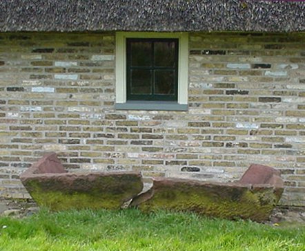
Some centuries later stories about this city become popular when fishermen find large pieces of stone in their nets and stone sarcophagi are discovered in the desolate peat- and moorlands south of Wieringen. (the churches in Hippolytushoef and Oosterland show some of these stone coffins).
In this respect, the legend surrounding the Koningsweg (Kingsroad) is very interesting. It runs from a point called the
Quarantaine at the most western point of Wieringen eastward and ends where the Burgerweg starts. The Burgerweg is a road in a small polder at the south-east point of Wieringen. According to legends unsupported by any evidence, the Frisian king Radboud built this road in the 8th century to get from his residence Medemblik to his huntingdomain on Wieringen. The name Burgerweg doesn't refer to civilians (Burgers) but to a royal stronghold ("Burg") that supposedly stood at the end of the Kingsroad. Bremer in his book "Wiringherlant" does not subscribe to this theory. He takes it much more likely the Kingsroad was part of a system of metalled roads made by the Carlovingians to ease their army movements. He thinks the road continued through the present IJsselmeer and connects near Workum, Friesland to the early medieval Gravinneweg (Duchessroad) that leads to Sneek.
 | One of the stone sarcophagi found near Wieringen, presently to be seen outside the museum Jan Lont at Stroe |
The large stones were sold to Amsterdam merchants, who found out while building houses of it, that it was very poor quality stone.
In hindsight, it is even questionable if it was stone at all. Before the 13th century only the largest cities were built from stone, and paved roads were out of fashion ever since the Romans left. A more probable explanation is that the socalled stones
were lime hardenings caused by the making of dikes from seagrass.
Nevertheless, in the early middle ages there have been numeral villages in the area around Wieringen (north in what is now sea, west in the Anna Paulowna Polder and the Wieringerwaard, and south in the Wieringermeer), and it is safe to assume that at least one of them had a name like Grebbe.
In the southern part of the Wieringermeer the remnants of the medieval village Gonsende or Gawijzend have been found, of which has been recorded that the village was lost some time around 1350.
The original Grebbe still has to be found.